SKYWATCH PROJECT: DETERMINING THE EARTH'S CIRCUMFERENCE
EQUIPMENT
REQUIRED FOR SUN OPTION: A stick at
least one foot long which can be driven into the ground (or a "plumber's
helper" works great!), a measuring device (tape measure or ruler), a
watch, a string with a weight tied to its end, a car, and gasoline.
EQUIPMENT
REQUIRED FOR POLARIS OPTION: Homemade
quadrant, as used for the first Skywatch, plus car and gasoline.
TIME
REQUIRED: Two days when you can make
(a) observations of the sun's altitude between 11:15 a.m. and 12:45p.m. PST
(equivalent to 12:15 p.m. to 1:45 p.m. PDT) or (b) observations of Polaris's altitude. One of these days should be in Seattle and
the other day at least 150 miles north or south of Seattle, say in Portland or
Vancouver, B.C. You need not go exactly
due north or south, but the experimental results are simpler to interpret if
you don't wander too far east or west.
Basically you need to go into Canada or south of the state -- Boise or
San Francisco are O.K., but Spokane or Walla Walla are not. If necessary, the observations can be made
several days apart (or even weeks apart), but then a correction for the sun's
changing position needs to be made.
Even for observations on consecutive days, your answer will be more
accurate if you allow for this -- use the table of solar declinations given in
the "Celestial Navigation" handout.
BACKGROUND: Eratosthenes (ca. 276-192 B.C.) was a Greek
scholar in the Egyptian city of Alexandria, the great center of learning of the
Mediterranean world in the days of the ascendancy of the Roman Empire. He is credited with having applied simple
geometric reasoning to obtain an excellent estimate of the earth's
circumference. His derived value
appears to have been within 10% of today's accepted value, but more importantly
his reasoning was clear and correct.
The accuracy of his estimate was limited only by the precision of the
instruments he used, as well as his value for the distance between Alexandria
and Syene (present day Aswan).
Eratosthenes's method can also be used by you today.
PROCEDURE
USING THE SUN: At each site drive a
stick into a level, smooth (ideally no grass) piece of ground, making it as
close to vertical as possible (holding a string and weight can provide a
reference). A "plumber's
helper" can also serve for your gnomon. Beginning about 12:15 p.m. PDT (or
11:15 a.m. PST) carefully measure and record the length of the stick's shadow
every 10 minutes. Continue this until
you are certain that you have observed the shadow at its shortest. Before you remove the stick from the ground,
carefully measure the length of that part of the stick above ground. This
procedure should be exactly repeated at each site.
PROCEDURE
USING POLARIS: Use your quadrant to
determine the latitude at each site using Polaris. The advantage with Polaris is that the observations are not
complicated by doing them on separate days, although they still should be
carried out at the same time of night, since Polaris is not exactly at the
north celestial pole. If you do observe at different times of the night, use
the method in the "Celestial Navigation" handout to find the required
correction.
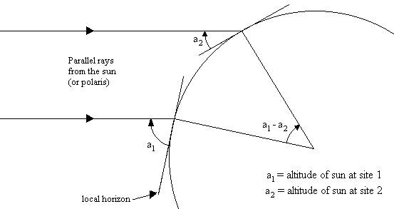
CALCULATIONS: The attached sketch lays out the geometry
that Eratosthenes used for his determination of the Earth's circumference. Apply simple trigonometry to convert your
measurements of the shadow's length to the altitude a of the sun at local noon at your two observation points. Simple geometrical considerations will show
you that the ratio of the north-south distance d to the entire
circumference of the earth C is equal to the ratio of the angle (a1 -a2 ) (which you have measured) to a full circle of 360
degrees. In other words:
d a1
– a2
¾ = ¾¾¾
c 360O
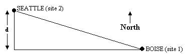
If
your two sites are close to being north-south and the road is reasonably
straight, then you can find d from
your car's odometer. In other cases,
and for greater accuracy in all cases, d
should be measured on a map as the north-south component of the separation
between the sites. For example:
You
can now solve for the circumference of the earth and consider yourself a
geodesist. You naturally will want to
compare your result with the accepted value, as well as check your measured
value of (a1 -a2) with the difference in
the latitudes of the two sites. The Times
Atlas of the World, available at Suzzallo Library Reference, is one good
source of latitudes for towns.